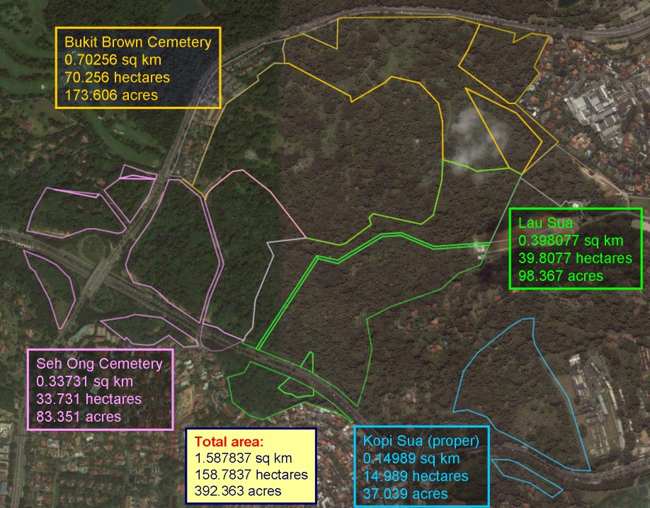
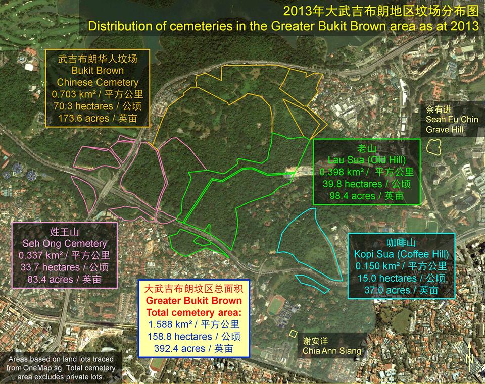
Just how large is the area of the Greater Bukit Brown complex consisting of Bukit Brown Cemetery, Seh Ong, Lao Sua and Kopi Sua? Mapping expert Mok Ly Yng has done the number crunching in this map
At nearly 400 acres, the Bukit Brown complex has over 200,000 tombs, which makes it the largest Chinese cemetery outside of China.
A member of the facebook group Heritage Singapore – Bukit Brown Cemetery recently posted a series of maps and articles which pointed to coolies living in Bukit Brown in 3 blocks, near Block or Hill 3. The coolies would most likely have worked on the maintenance of the tombstones and the cemetery.
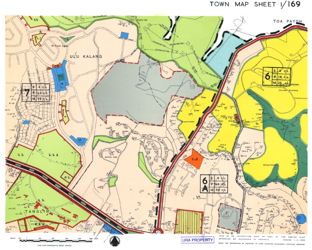
1958 map showing the “cooly lines” of 3 blocks, at the yellow section just above the number 6 on the right line (Map Source: URA)
According to the posts
“Both the 1958 town map & NAS’ BBC map show 3 blocks of “Coolie Lines” (ie. indentured labourer housing) along the tarmac road at Block 3 (at the demarcation between Div A & B ), a short distance before the “eco-bridge” that overlooks the stream.
http://www.nas.gov.sg/docs/Bukit_Brown_Map-1.jpg
http://www.ura.gov.sg/dc/mp58/dcdmp58tm169.htm
The said “coolie lines” could’ve already existed when BBC (estd. Jan 1922) was still the private burial ground of Seh Ong clan. In Oct 1928, the structures were reported to be “in a very dilapidated condition, and it is proposed to rebuild them”. In Aug 1929, Lian Hup Co. won the tender ($6,200) to erect the proposed new “Coolie Lines”.
As it was common to have resident indentured coolies living in cemeteries, might some of the paupers’ or unknown/ unmarked graves at BBC belong to these resident coolies ?For instance, when ~237 WWII-era tombs at BBC were exhumed in 1965 for the realignment of Lornie Rd, the exhumation list included 2 plots whose residential addresses were stated as “coolie lines”. For the “Unknown” plot, the burial date was 05 Jul 1942, & the address was “5 Coolie Lines SHB” (in this case, the Cantonese coolie lines of S’pore Harbour Board).”
Extract from Infopedia on Coolies : Chinese coolies formed the early backbone of Singapore’s labour force, engaged mainly in hard physical labour. They were mainly impoverished Chinese immigrants who came to Singapore in the later half of the 19th century, seeking their fortune but serving instead as indentured, unskilled labourers. Coolies were employed in almost every sector of work including construction work, plantation work, in ports and mines and as rickshaw pullers.
The Archived Newspaper Reports:
* SG Free Press (23 Oct 1928) – Proposal to rebuild dilapidated coolies lines at BBC: http://newspapers.nl.sg/Digitised/Article.aspx…
* SG Free Press (28 Aug 1929) – Lian Hup Co. awarded tender to rebuild coolie lines at BBC: http://newspapers.nl.sg/Digitised/Article.aspx…
* ST (26 Mar 1965) – PWD Exhumation Notice for BBC (Lornie Rd alignment): http://newspapers.nl.sg/Digitised/Article.aspx…
As part of Bukit Brown : Our Roots, Our Future, a series of talks were programmed to enrich the exhibition which was held at the Chui Huay Lim Club, the co-organiser of the exhibition.
Here are the video recordings, released with kind permission from the speakers.
Sunday, 20th June 2013
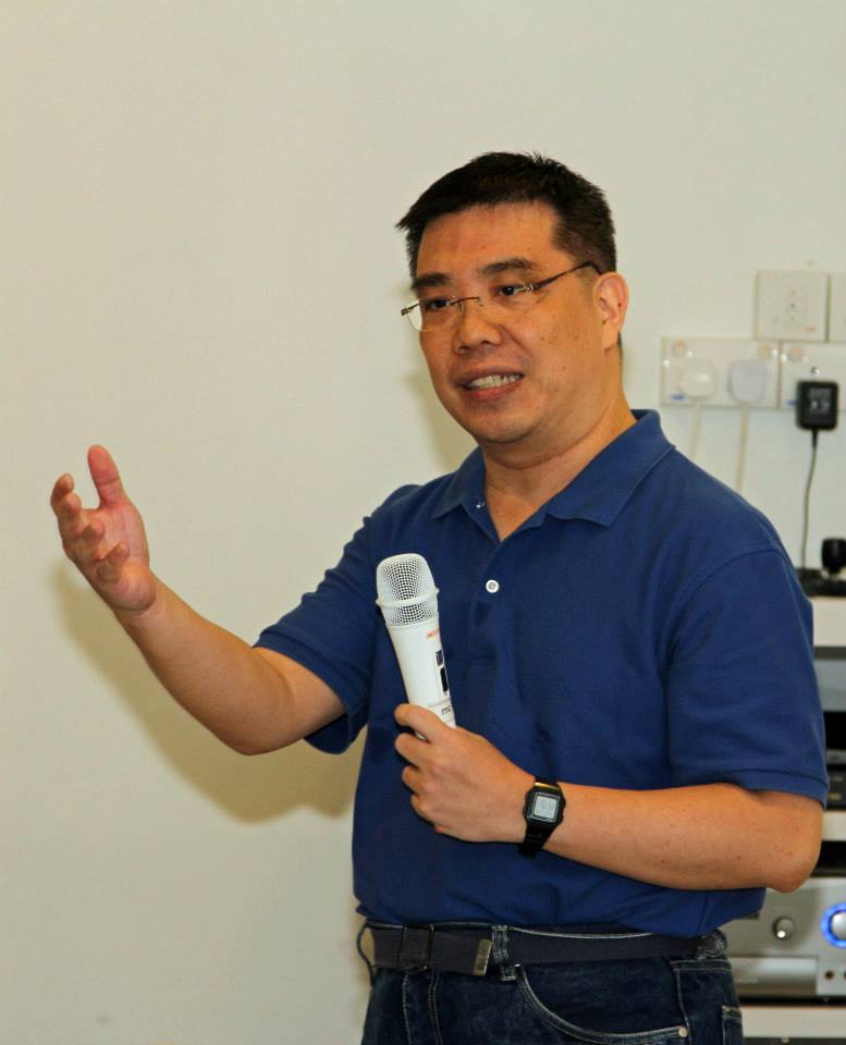
Mok Ly Yng – A Historical Survey Of Bukit Brown
This historical survey of maps reviews the geography and distribution of cemeteries in Bukit Brown and its environs. It also traces the development and changes of the area from the mid 19th century to the 21st century.
Speaker’s bio: Mok Ly Yng is a freelance GIS consultant and map researcher. He received his M.Sc. in Geographical Information Systems (GIS) from the University of Edinburgh. He had worked previously in the Mapping Unit and the National Archives of Singapore.
Dr Ho Hua Chew – The Ecological and Biodiversity Importance of Bt Brown.
Having become forested through several decades of wild vegetation growth after being degazetted as a cemetery, the area generally has become attractive to many wildlife, in particular the forest birdlife. The talk will focus on the important and interesting forest wildlife that is recorded in the area.
Speaker’s bio: Dr Ho Hua Chew is the Vice-chairman of the Conservation Committee of the Nature Society (Singapore) as well as a Council member of the Society. He has been involved in conservation projects for the Society as a volunteer since the late 80s, including the formulation of Sungei Buloh conservation proposal and the Master Plan for Nature Conservation in Singapore.
Charles Goh – All things paranormal in BBC
Singapore’s own ghost buster, shares stories from beyond the graves, and findings from his investigations in paranormal activities.
Speakers bio : Charles Goh is the founder of the Asia Paranormal Investigators (API) which is a paranormal research based Society based in Singapore. API that strives to systematically analyze any strange occurrences happening in Singapore and around the region. Charles a trained guide with STB credentials has conducted many night tours at Bukit Brown
A very big THANK YOU to Brownie Ang Hock Chuan for videoing the talks!
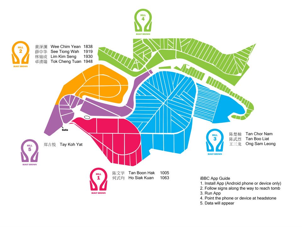
The iBBC App Guide is a FREE App to accompany you when you visit Bukit Brown Chinese Cemetery. It has been developed by the The Bukit Brown Cemetery Documentation Project led Dr Hui Yew Foong. Brownie Khoo Ee Hoon designed the artwork of the map. There will be physical markers on site to guide the way.
Download your App from the Google Android store now, here
Check out a video demo on how it works here
And once you have downloaded you can test the application here before heading to Bukit Brown!
Note: This is a sample of a few tombs. The the App itself has data of over 20 tombs introducing you to the pioneers buried there.
Those with accompanying numbers e.g. Tok Cheng Tuan 1948 are staked and and will be exhumed. to make way for the eight lane highway. You only have a few months left before you can catch this tomb in all its magnificent glory.
Please note Updated 3 of Map.
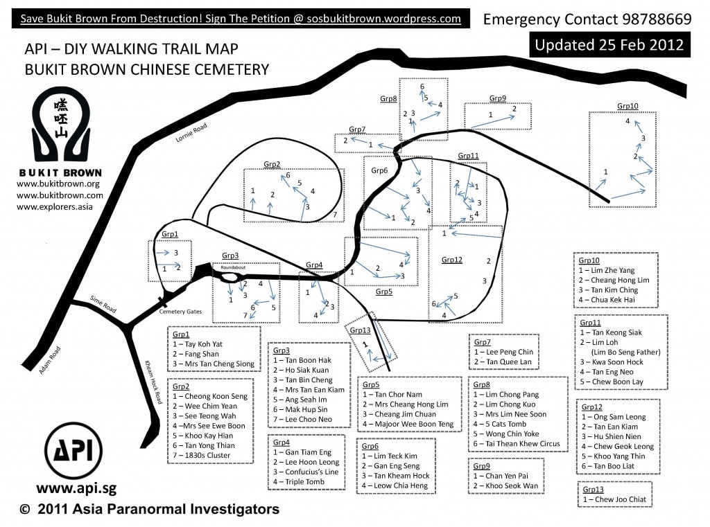
Hot off the press updated map from Goh brothers who have also done maintenance work on red and white markers. Self guided tours now a breeze. Enjoy
Having issues, go direct to the source
For an interactive rendition of this map, created by Pui Cuifen and assisted by Lim Su-Min, among other Bukit Brown elves, click here and zoom in.
The map below is useful for navigating Bukit Brown in tandem with map with tombs of interest.
For self-guiding, please refer to our tour guides and featured tombs. Read up on tips before you visit for full enjoyment and safety. Enjoy the flora and fauna.
***
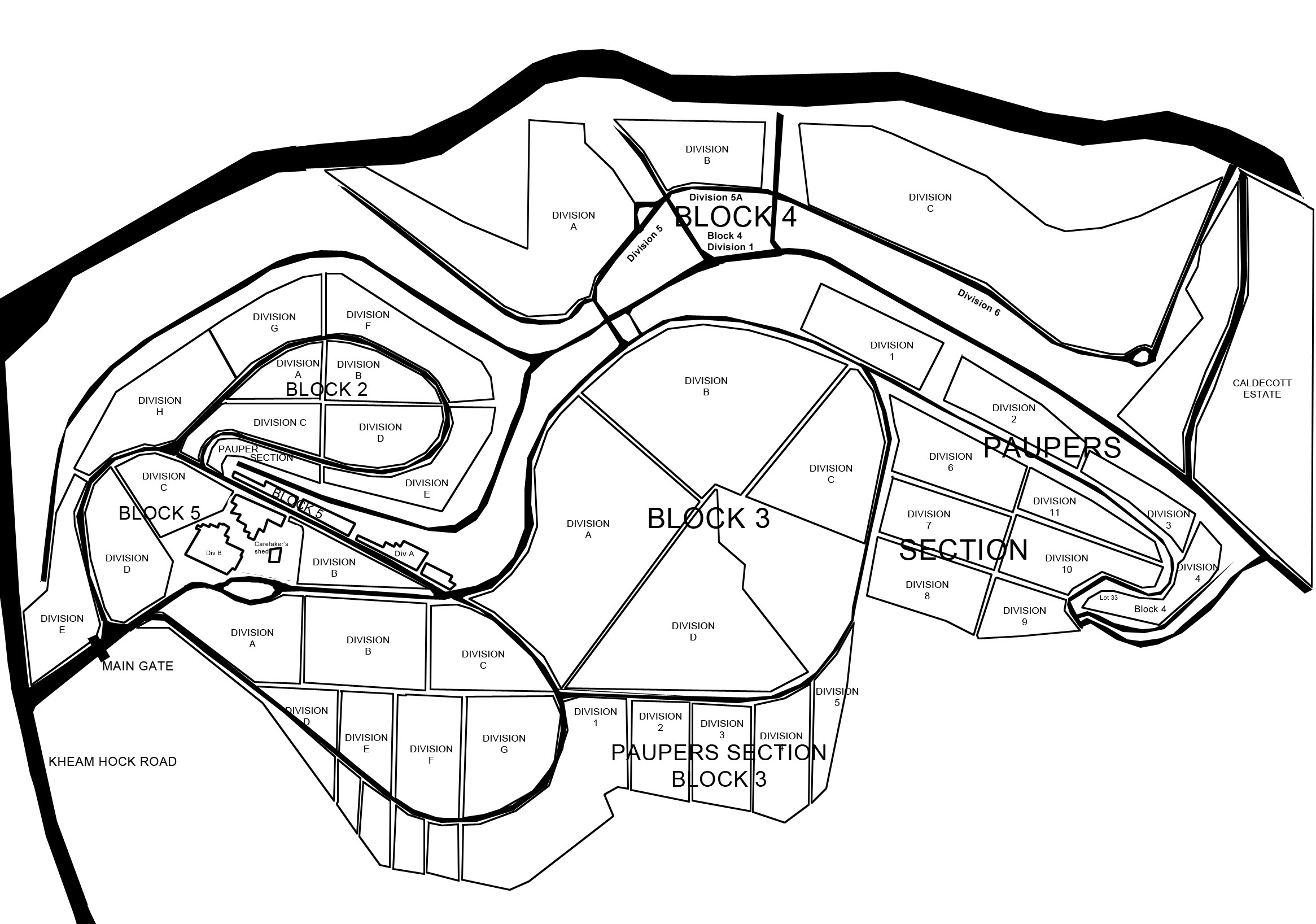
Division Map
***
We are often asked about the distances over Bukit Brown. Cyclists and runners may find these useful:
For the greater Bukit Brown cemetery complex:
Mok Ly Yng says:
The Seh Ong Cemetery was made up of 5 hills since day 1. Lornie/Adam Road only cut thru the valley between Hill 4/5 (on the golf course side) and the rest of Hills 1-3 on the BBC side. Then later on, PIE came in and cut thru the lower areas of the Hills 1 and 2.
Seh Ong had 5 hills since the area was acquired in the 19th century. Still today, the hill tops are still around, but the ‘body’ of the hills are badly bisected by the two roads (Lornie/Adam Rds and PIE).
Kheam Hock Road also cut thru a valley between the Seh Ong Hills 1 (left) and 2/3 (right), does not affect the hill count.




Recent Comments